Thinking about adding a new deck, ADU, or a full rebuild near one of Edina’s smaller lakes? Lakeside living comes with extra layers of rules and design choices that can affect where you can build, how big you can go, and how you manage rainwater. With the right plan, you can protect your schedule and budget while creating a home that fits the setting.
This guide walks you through who regulates what, the site constraints that shape design, realistic timelines and costs, and a step-by-step checklist to start strong. You will leave with practical tips to talk with your architect, builder, and reviewers. Let’s dive in.
Who regulates shoreland work
Building near Edina’s lakes involves several agencies, each with a different role. Getting oriented early prevents surprises later.
- Minnesota DNR. The DNR sets statewide shoreland standards and definitions. Start with the state’s overview of terms like Ordinary High-Water Level, often used to measure setbacks, on the DNR’s Shoreland Management page. You can review those state-level basics in the DNR’s overview of Shoreland Management.
- City of Edina. Local zoning controls setbacks, height, impervious coverage, ADUs, and permits. Edina can be more restrictive than state minimums, so confirm parcel-specific rules through the city’s Planning & Zoning and Building pages.
- Watershed districts. Stormwater and shoreline work often require watershed permits. In Edina, confirm whether your parcel falls under the Minnehaha Creek Watershed District or the Nine Mile Creek Watershed District. In some areas near the city boundary, you may need to check neighboring entities like the Bassett Creek Watershed Management Commission.
- MPCA and Minnesota Stormwater Manual. State stormwater standards and best practices are administered by the MPCA. For expectations on construction-phase and post-construction stormwater, see the MPCA’s stormwater management overview and the technical guidance in the Minnesota Stormwater Manual.
- Hennepin County. County resources and GIS can help identify floodplain, wetlands, and septic records. Start with the county’s environment and community resources.
Key site constraints
Understanding these constraints helps you align your design with review standards and avoid late redesigns.
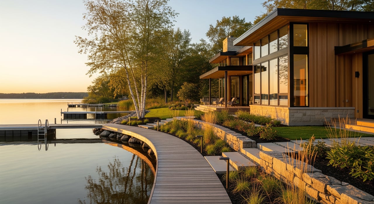
OHWL and setbacks
The Ordinary High-Water Level is the reference line for most shoreland setbacks. A licensed surveyor or civil engineer typically identifies it on site. Many Minnesota ordinances use at least 50 feet as a baseline setback from OHWL, but local codes can be more restrictive. In Edina, always confirm exact distances and how they apply to houses, decks, and accessory buildings.
Design impacts:
- House massing may shift away from the lake or move upward to stay inside setbacks.
- Decks and patios can be treated differently than houses. Low, open decks may have different rules than roofed or enclosed structures.
- ADU placement must meet shoreland setbacks and also fit within lot coverage and impervious limits.
Vegetation buffers
Shoreland rules often limit removal of native vegetation near the lake. Removal may require mitigation, such as planting native buffers.
Design impacts:
- Paths, patios, or view corridors should balance access with erosion control.
- Where you remove vegetation, plan for restoration using native plantings.
Impervious and stormwater
Edina and watershed districts commonly cap impervious coverage and require treatment for new or expanded impervious areas. Many stormwater programs use a water quality volume approach that targets the first portion of runoff from added hard surfaces. Confirm the exact triggers with your watershed.
Design impacts:
- Smaller footprints, second-story additions, or permeable surfaces can keep you under thresholds.
- ADUs, driveways, and large decks add impervious coverage and may trigger watershed permits or treatment.
Soils and infiltration
Infiltration-based practices depend on suitable soil and groundwater separation. Many watershed rules require infiltration or percolation testing if you plan to infiltrate runoff.
Design impacts:
- Poorly draining soils push you toward alternatives like bioretention with underdrains, sand filters, or approved proprietary units.
- Near-lake foundations may need special engineering if soils are weak or groundwater is high.
Floodplain, wetlands, and shore structures
Work waterward of the OHWL, or changes to docks, retaining walls, or wetlands, can trigger additional reviews.
Design impacts:
- Retaining walls and hard shorelines are often discouraged. Soft or living shoreline techniques may be preferred.
- Docks and piers usually have their own dimensional and permitting standards.
Design moves that work
Smart design can meet your goals while staying compliant and cost-aware.
Compact massing
- Favor a compact footprint and vertical expansion to respect setbacks and coverage caps.
- Cluster additions away from slopes and buffers to minimize grading.
- Relocate utility and service spaces to less sensitive parts of the lot.
Decks, porches, and ADUs
- Use elevated, open deck designs on piers where allowed to limit fill and reduce impervious area.
- Keep roofed or enclosed structures out of buffer zones when possible.
- If considering an ADU, explore converting or reusing existing structures before adding new footprint.
LID and stormwater practices
- Prioritize infiltration options like rain gardens or permeable pavers if soils allow.
- Where infiltration is not feasible, consider vegetated filter strips, sand filters, or watershed-approved proprietary units.
- Disconnect roof downspouts to flow across vegetated areas or into BMPs instead of piping directly to the lake.
Vegetation and shoreline
- Preserve native vegetation near the shore and use narrow view corridors instead of wide clearings.
- Combine native plantings with minimal structural elements for erosion control where needed.
- Plan mitigation plantings if vegetation removal is unavoidable.
Permits, timing, and costs
A clear roadmap and realistic budget save time and stress.
- Common permits. Expect a City of Edina building and zoning permit, plus watershed permits if you add impervious area, alter drainage, or work near the shoreline. Septic, floodplain, or DNR approvals may apply depending on the scope.
- Review timelines. Watershed reviews typically run about 20 to 45 days after a complete application. City site plan and building reviews often take several weeks, with longer timelines if you need a variance. DNR-related approvals can add weeks to months.
- Typical cost categories. Plan for a boundary and topographic survey with OHWL ($800 to $3,000), infiltration tests and geotechnical borings ($500 to $3,000), and civil or stormwater design ($1,500 to $7,000) for small residential projects. Watershed fees can range from a few hundred to several thousand dollars based on added impervious area. Mitigation plantings or shoreline restoration may range from $1,000 to $10,000. If a variance is needed, include application and possible consultant costs. These are illustrative ranges and will vary by parcel and scope.
Early action checklist
Use this sequence to protect your schedule and budget.
- Confirm zoning, shoreland overlays, and the correct watershed district for your parcel through the City, county GIS, and watershed maps.
- Order a boundary and topographic survey that locates the OHWL, utilities, septic, and existing impervious area.
- Conduct soil infiltration tests where you might install BMPs and near proposed foundations.
- Request pre-application meetings with City of Edina planning and the relevant watershed district to clarify triggers and likely requirements.
- Prepare a conceptual site plan that shows massing, impervious changes, and a sketch of how stormwater will be managed.
- Get preliminary engineering and cost estimates for stormwater before you finalize architectural plans.
- Apply for permits early and build contingency time for watershed reviews, potential variance hearings, and any DNR involvement.
- Include a budget contingency for mitigation plantings, extra testing, and potential off-site stormwater solutions.
Real-world scenarios
Adding a lakeside deck
If your deck is low and open, your local code may treat it differently than a roofed or enclosed porch. Whether it counts as structure or impervious area affects setbacks and stormwater triggers. Confirm definitions with Edina and the watershed before design.
Building an ADU near the shore
ADUs can fit near-lake settings when they meet shoreland setbacks and lot coverage rules. Watch impervious thresholds that may trigger watershed permits or stormwater treatment. Sharing utilities and reusing existing structures can reduce footprint and reviews.
Full rebuild or major addition
A full rebuild will involve a complete look at setbacks, impervious totals, and stormwater treatment. Engage a surveyor and civil engineer early to locate OHWL, test soils, and sketch BMPs before committing to final plans. Expect a longer review cycle and add schedule contingency.
How to avoid delays
- Confirm the watershed district first. Use the Minnehaha Creek Watershed District or Nine Mile Creek Watershed District resources to verify boundaries and permit triggers.
- Learn the shoreland basics. Start with the DNR’s overview of Shoreland Management and Edina’s Planning & Zoning pages.
- Align design and stormwater early. Reference the MPCA’s stormwater management guidance and the Minnesota Stormwater Manual for sizing approaches, then validate requirements with your watershed.
Ready to plan your near-lake project or find a lot that fits your goals? Reach out for local guidance, introductions to trusted surveyors and engineers, and a plan that respects shoreland rules without sacrificing lifestyle. Josh Sprague can help you identify opportunities and move with confidence.
Edina’s small lakes offer a unique blend of design opportunity and everyday lifestyle, and pairing that with a broader view of the market helps buyers and homeowners make confident decisions. Reviewing current Edina homes for sale is a great way to understand what’s available city-wide, and this month’s Neighborhood Spotlight featuring Dewey Hill highlights one of Edina’s most established and distinctive areas.
FAQs
What should I check first for an Edina lakeside project?
- Start by confirming zoning, the shoreland overlay, and which watershed district governs your parcel, then order a survey that locates the OHWL.
How are setbacks measured near lakes in Edina?
- Most shoreland setbacks are measured from the Ordinary High-Water Level, which a surveyor or civil engineer identifies; confirm exact distances with the City of Edina.
Do decks count as impervious surface near the lake?
- It depends on local definitions; low, open decks may be treated differently than roofed or enclosed structures, so verify how Edina and your watershed classify your design.
When do I need a watershed permit in Edina?
- Watershed permits are commonly required when you add impervious area, alter drainage, or work near the shoreline; confirm triggers with your specific watershed district.
What if my soils do not infiltrate well?
- You may need alternatives like bioretention with underdrains, sand filters, or approved proprietary units, which can add design complexity and cost.
